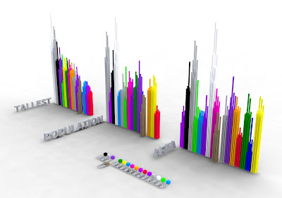
SkyLine is a visualization of what it means to be a "big" city. Portland is known as a little big city and i was curious as to what that meant. I researched 16 cities and collected data on their tallest buildings, population, and area.
Through my data collection I created a skyline of America. The cities i chose all came to mind when i thought about big cities in America.
Seattle, Portland, San Francisco, San Diego, Los Angeles, Las Vegas, Salt Lake City Austin, Houston, Oklahoma City, Chicago, Detroit, Boston, New York City, Wshington DC and Miami.
To start I collected the top 9 tallest buildings from each city and phyisically combined them to create a SkyScraper for each city.
This is a digital model showing these SkyScrapers arranged by city area, population and Building height.
 I also created a 3D visualization of SkyLine out of lazer cut MDF showing the SkyScrapers placed acording to location across a plane of the united states. The ground plane is meant to disappear as the SkyScrapers jut out of it. The circles around the each SkyScraper are a scaled representation of the city area, combined with the height of the buildings it gives an idea of densisty and urban sprawl. You will notice that Oklahoma City has one of the shortest SkyScrapers but the largest city area.
 This image is looking West from the East Coast and is focused on Portland.
 This is looking up the west coast from what would be Mexico. Portland and Seattle are the focal points.
 The SkyLine from the South East
 Constructing the SkyScrapers
 Assembly and area indicator detail
No comments:
Post a Comment